Pages

Tuesday, March 7, 2017

March 6, 2017: First Chase of Season / Earliest Tornado Record in MN??


March 6 - 2017: Wright County / Mc Leod County to Sherburn County.

An early spring severe weather outlook day produced large hail and damaging winds; and tornadoes in MN. This will mark the earliest date in MN histroy that a tornado was ever recorded. The previous record for this happening was March 18, 1968.

We left early in the afternoon and targeted Southern Wright County. We intercepted the storm that was racing to the northeast form near Redwood Falls.

Our storm chasing mascot, Mr. Prairie Dog,  was able to get on his very first chase of the 2017 season. 

Here he is when we were trying to get on the line of storms moving to the northeast.

This picture was taken during the first tornado warning of the 2017 chase season. What a way to star off the season! This storm was in Wright County near Cokato where the storm on radar had a kink in the line, and visually she was turning by no means "much". We never witnessed any funnel or tornado with this storm. 

In this shot you will see the golf balls photo bombing my shot of the low topped supercell.


We kept following the storms as they raced to the northeast. Here in this picture is us riding the whales mouth where we blasted east just out ahead of this scorching fast line to take a peak just southwest of Buffalo, MN.


Here is another look at the storm, now looking north down the road.


We encountered 1.25" hail with this initial cell.


Once we heard of the damage reports up near Zimmerman, MN - we blasted north to try and get there prior to it becoming completely dark.

It was a serious situation in Sherburne County right near sunset - as it was evident that a very tight couplet presented itself in the bow of the storms with the QLCS line just west of the town of Zimmerman near Orrock. We arrived on scene just moments after the damage was done and encountered numerous large trees snapped and fallen; house and sheds with heavy structural damage, and many large power poles snapped off at their bases. Some barn tin was wrapped and tossed into the tress as well as the power lines. It looked like a tornado could not be ruled out here at this location; based on radar and damage.

The MPX NWS will be on scene March 7th to do the damage assessments.

Some damage photos:


Many rescue vehicles were on scene.


Here is Mister Prairie Dog with Nick in the background shooting video on scene of the tornado damage.

Most information will be posted later about the rating of the tornado when the NWS is finished with their surveys.

Be sure to follow us on our website: www.prairiewindchasers.com
Twitter: @PrairieWndChsrs
Facebook: amanda.hill.7399
for all the latest weather posts.

Our video from our chase can be viewed here: https://www.youtube.com/watch?v=CWZGpGDxnWc&t=20s

National Weather Service - Twin Cities Recap of March 6, 2017 Storms
http://www.weather.gov/mpx/March_06_2017_Severe_Weather_Summary


JULY 9, 2016 NORTH DAKOTA MONSTER HAIL


Mister Prairie Dog was happy to see some storms today. He normally likes to see tornadoes; but today he struggled to hoist this 2.5 inch tennis ball hailstone in his arms, that he went bonkers for in North Dakota today.

See our facebooks posts and images from this day on our website!


Thursday, July 28, 2016

May 22-23, 2016: Nebraska and MN


Sunday May 22

After the big Leoti Supercell/Tornado day we set up for the next day's target. Northern KS border and NE. 

We had dinner in North Platte, NE and was watching the radar develop a cell.

All of a sudden it popped, grew and became a storm. We got on ti from birth and followed it north on a tar road that turned into a sandy gravel road in where we had to let it go. Uncertainty of getting off the sandy gravel road with the car seemed nill so we went back the way we knew that would bring us back to tar.

But the sights, sounds and scenery we saw was amazing. 

We did manage to get this nice picture.


Monday May 23

Monday morning we traveled from North Platte, NE to Des Moines Iowa. We stopped to have lunch at our favorite BBQ joint there.

We saw that some storms were popping up - so we decided to follow them before heading north back for home.

We got to see some nice CG's and tried out the go pro for once.


The above picture is the storm we saw in Iowa prior to heading North towards home.

It was a fun, memory filled weekend!

Friday, May 27, 2016

May 21, 2016: Kansas Chase

Nick and I left after work Friday night to position ourselves for Saturday's Setup. Saturday we targeted the town of Sharon Springs, KS to see what the models and parameters woudl have around the lunch hour.

We got gas and ate a quick lunch at the 40/27 Gas Staion while looking at model data. We saw that we needed to head south, so we headed towards Tribune, KS. We went East of town a bit and sat. We watched the CU field form. As things started to get going we headed East towards Leoti, KS and a bit north of town. 

The cu field we watched exploded into a massive supercell.


CU field starting to form that afternoon.


Nick watching the skies for possible development.


We watched this cell near Selkirk. This cell would explode and become the dominat super cell storm that produces multiple tornadoes.

We followed this cell to the East to Leoti. Then then went north of town.

Here the majestic supercell showed it's true beauty.


Start of the storm - rain foots.


Wall clouds starting to define on the cell.

Pure luck capturing this smiling lightning arc across the supercell forming in front of our eyes.


The supercell is starting to tightly assemble into a barberpole spaceship type of look. Taking in inflow from the right.

The supercell then formed a wall cloud and then soon the tornado appeared.


Tornado!

The rain started to shroud the tornado and it quickly lifted afterwards.
We continued to stay with the storm. Here are some more pictures from after the tornado.

Lightning in the sky after the tornado.


The mothership and inflow band into the storm.

Mammatus treated us right at sunset.


Mammatus treated us right at sunset.

It was a spectacular day! A day that we will not forget for a while.


Monday, April 25, 2016

April 24, 2016: First Chase of the 2016 Season

We saw the slight risk slated for Sunday afternoon and the wording for possible supercells; and said we have to at least try it since it is so close to home.

Saturday afternoon we headed down to Iowa in search of cones. Ice Cream Cones that is.. at Le Mars, Iowa.

After a stop at the Ice Cream Parlor in downtown Le Mars; we set up ourselves with an overnight stop in Sioux City, IA.

Sunday morning turned our slight risk for a more northerly play along the SD/NE/IA/MN borders. We went west in the late morning and ended up going through heavy rain around Sioux Falls, SD.

The lightning show around Sioux Falls was awesome. Unfortunately we were driving the whole time and the rain was heavy and could not take any pictures.

My our chase mascot was happy he was out for his first chase of the year. It was a good test of the equipment and we are ready to go.

Bring on the storms Mother Nature!!

Here are a couple pictures from the day.


Our very long time chase mascot: Mister Prairie Dog. Here is his kicking off the 2016 chase season near Nebraska.


One of the very few, if not only storm, that tried to remain discrete along the dryline in Eastern Nebraska. When we pushed on the other side of the small hail and rain core; we were treated to this great spectacular sky.

Severe Weather Awareness - the rest of the topics

Things got a bit busy towards the end of Minnesota's Severe Weather Awareness Week, but here is the rest of the topics that were covered

Flooding

Flooding is something that you do not want to mess around with. Remember - Turn Around - Don't Drown! 


Tornado Safety

As the severe weather season starts to ramp up - here are some very important Tornado safety information that you should be aware of.


and Lastly Heat.....

Heat Waves Kill. From 2000-2010, there was 35 deaths that were directly attributable to the extreme heat in Minnesota.  When heat related products are going to be a part of the forecast, the National Weather Service will put out a couple of products.

Excessive Heat Outlooks will be issued when the potential exists for an excessive heat even in the next 3 to 7 days. This outlooks provides information to those who need considerable lead time to prepare for the event

Excessive Heat Watches: These are issued when conditions are favorable for an excessive heat even in the next 24 to 72 hours. The watch is issued when the risk of a heat wave has increased but the occurrence and timing is still uncertain. It provides enough lead time so those that need to prepare, can do so.

Excessive Heat Warning/Advisories are issued when excessive heat event is expected in the next 36 hours. these are issued when an excessive heat event is occurring, is imminent or has a very high probability of occurring. the warning is used for conditions posing a threat to life. an advisory is for less serious conditions that cause significant discomfort or inconvenience and if caution is not taken could lead to a threat to life.

Heat Index Chart.
Heat index is sometimes referred to the apparent temperature given in Fahrenheit. The heat index is a measure of how hot it really feels. Kind of like our windchill factor, but opposite.

Below is a chart to keep handy on those heat days.


Tuesday, April 12, 2016

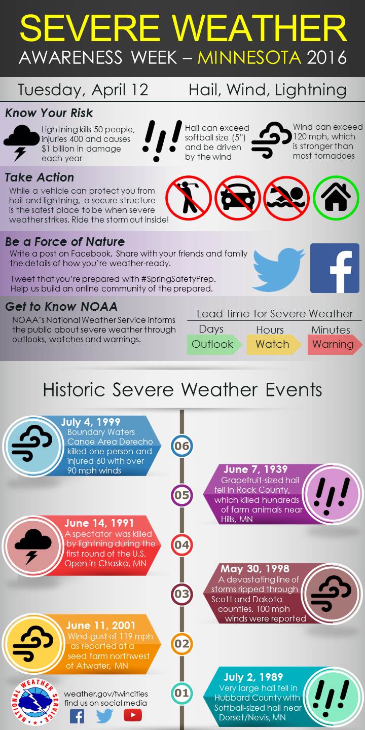
April 12: MN Severe WX Awareness Week : Severe Storms, Lightning and Hail

Today the topic is Severe Storms, Lightning and Hail. Below is a graphic that can help better understand how to prepare for these events and stay safe!


Remember - When Thunder Roars - Head Indoors!

Monday, April 11, 2016

MN Severe Weather Awareness Week April 11: Watches & Warnings


It's that Annual time again - when we reflect on Severe Weather Awareness Week in MN.

Every year around this time it is great to brush up on the terminology and prepare ourselves for the upcoming season. Today's topic is below. Stayed tuned the rest of the week for the rest of the topics!

Monday April 11th - Watches and Warnings

We reflect on the terms of Watches and warnings in severe weather. Do you know the difference? Here is a handy graphic to explain it all!


Thursday, August 13, 2015

August 8, 2015: North Central Minnesota Storms

With the big severe risk down in Nebraska all depending on if the morning MCS and cloud cover could recover; we decided to stay local.

Storms were beginning to build and fire off to our North; so Nick and I went towards the trees of MN and chased the storms that fired between Garrison and Grand Rapids.

We sat just south of Hill City in an somewhat open field area to watch the approaching storm.


Once the hail starting coming our way, we dove south just a bit to the road that goes to Lake Waukenabo. We stayed there until the hail got close, we then drove a bit south and let the hail core pass off to our north.


We drove north to test the winds; and we saw at least dime sized hail along side of the road. We retreated back to the south and to the east a bit to take another look of the storm.


We then proceeded south to head home.

We stopped by a sunflower field (which is rare this far north!) to take a few photos.


We were treated to a nice sunset on the storm that was just north of the metro as we drove home. what a treat!


A fun little chase up in the Northwoods.

Sunday, July 19, 2015

July 5, 2015: West Central Minnesota Cold Front Chase

We enjoyed the holiday weekend out in Western MN. We knew there was a chance of storms on Sunday; and with not wanting to head back to the cities any time soon in the afternoon due to all the traffic heading back in; we stuck out in Western MN waiting for the storms to fire.

The SPC had an enhanced risk out all day for this area.

20150705 2000 UTC Day 1 Outlook Graphic

A cold front in the Dakotas was crossing and was supposed to fire off storms in the afternoon. The models kept showing the storms blowing up over Western MN. We sat waiting in the hot afternoon; full bore sun near Ortonville, MN.

We kept watch for any sign of CU to form off to the west.

Finally something popped up on radar.

We skirted across the border at Ortonville and stopped under a tunnel that went under the railroad bridge. We watched as the storm approached. We thought the hail was coming towards us; but instead it went to the south and west.

Since we saw the storm just not produce anything, we retreated back across the border to MN and started to head our way home via Hwy 12 to Hwy 9 to Hwy 55.

The lightning was weak with the storms as well.

The cold front just stalled and really did not move much at all until way late in the evening.

Below is a shot of the storm when it was near the town of Corona, SD.


The storms just could not get themselves going today with the cold front just stalling out. we headed on back to the cities the back roads as I94 was still full of slow holiday traffic.


July 12, 2015: Western MN Moderate Risk Tornado Day

Since Saturday morning we knew that Western MN would be a big show day - and possible the most severe day in Minnesota this year.

We went out to the farm after stopping by Jessica Becker's graduation party in Buffalo.

We went to watch the fireworks show in Morris for the Prairie Pioneer Days. Below is a couple of shots from the show.


Sunday - we woke up to moderate risk; and started to make sure the people was aware of the situation that could unfold that afternoon. Two big events were in the area. Big Stone County Fair in Clinton and the Prairie Pioneer Days in Morris, MN.

201507121327 PWO graphics
The Public Weather Outlook issued by the SPC @ 8am CDT

The models all kept showing cells to blow up right around the Fairmount, ND area.

With the car set up and all the batteries charged - we set out for Fairmount, ND to wait things out. We had a quick lunch at the gas station and then went and sat and waiting just outside town. We had a few pop up showers come over us, but the cu field was trying to go.

We headed back east to Hwy 75 and went a bit north and sat on a dirt road. This cell was starting to look like it could do something.. and sure enough - we saw a small needle funnel.


The storm as it got going.

A few minutes later this small needle funnel appeared.


another cell showed us a small needle funnel as well.
We went further up the north on Hwy 75 and quickly pulled off by a farmers house; as we saw rapid circulation. As soon as we got out of the car, the tornado appeared. We were looking to the northwest in these following shots. This was just south of the small town of Duran, MN

Shot as it was appearing out from the farmers grove

Getting a better view of the circulation on the ground - whole storm shot.

Tighter shot of the tornado as it was near the edge of the grove

Well formed tornado in this shot.

Tornado starting to become more of a bowl shaped cone.


The tornado quickly was dissipating - and soon would be gone right after this.

Complete rope out stage.

A rule to always to keep your head on a swivel - another tornado was formed and on the ground to our southeast of our location.

Looking Southeast towards the near tornado that did not last very long.

After this we tried to head east to keep up with the storm. We followed it out of Doran, MN - and continued east. We started to run into hail so we dropped back and bit and tried to find a road heading south. We ended up going to Wheaton on some back roads; then onto Hwy 27 towards Herman, MN.

At this point we called our friends for Stevens County EM to give them the all clear as everything went to the East of them.

Outside of Herman, MN along Hwy 27 we ran into Eric Whitehill. We stopped and chatted, and observed the storm from here.

Our two chase vehicles

Eric and Nick
Wannabe cloud - a scud tag hanging from the base of the storm.

We left Eric and headed east towards Hwy 59. We went south on Hwy 59 and then cut east on some gravel road and ended up on hwy 28. We kept going east on Hwy 28, with the storm off to our north.

In Starbuck we stopped to get gas and then went south of town as another tornado warning was issued.
Shot of the storm as it was going over Lake Minnewaska.

Looking north along a side road off County Road 18 in Pope County, MN


Looking east along County Road 18 in Pope County, MN

From here we left the storm. It was starting to go into a line and we wanted to stay ahead of the rain. we made it into the cities around 11pm that night and the rain was just on our tail. We quickly unpacked the necessary items to not leave in the car and called it a night and watched the rain and wind come down.

The Big Stone County Fair thanked us for keeping them in the loop for any potential severe weather and was glad that nothing came there way.

It was a fun little chase day!