Pages

Friday, August 17, 2012

8-15-12: West Central MN Severe Storms

Mother Natures biannual battle of the seasons has once again kicked off over the upper Midwest, and on this past Wednesday evening the fight was waged over the skies of Stevens county!

On Wednesday afternoon the atmosphere over west central Minnesota was set up and primed for severe weather. At midday a very strong cold front was situated northeast to southwest over the far eastern Dakotas. This sharp boundary marked the leading edge of a much cooler and dryer even fall like air mass into the region. As the front pushed across the border severe thunderstorms rapidly developed over portions of Big Stone and Traverse counties around 4:45pm and by the 5:00 hour the storms were wreaking havoc well into Stevens county.


The start of the storm put us in Big Stone County.

 A really cool and interesting updraft near Clinton, MN in Big Stone County - MN. It almost looks like a perfect bomb blast and mushroom cloud!


Looking northeast up into the main action area on the far southwest end of the slowly southward back building line. We had a small brief wall cloud show up west of Graceville, MN, but it was mainly undercut from the get-go.


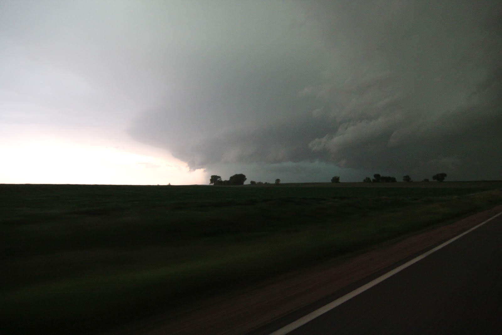
The storm is now more outflow dominant, as expected., and now developing a well more organized shelf cloud. Taken near Chokio, MN.


About to get blasted - time to head East!! East of Chokio, MN.


Here the shelf cloud is over Morris, MN.

Strong and gusty winds, very heavy rains as well as large hail with some stones reported up to 2 inches in diameter ( Hen Egg Sized ) greeted Morris and Donnelly residences as the storms quickly rolled through with a classic well defined shelf cloud on the leading front edge of the storm.

Hail damage was incurred to some of the buildings as well as many vehicles in the area, including the Morris city limits. 


 5 shot panoramic view of the city of Morris getting ate by this beast producing hail up to hen egg size at this moment.


Here the shelf cloud is now in Pope County, MN just south of Starbuck,MN. The CG illuminated the core as it moved East.


The shelf cloud is starting to blast southeast at 35 MPH in Pope County, MN.


Starbuck Fire Department was out weather spotting just southeast of town, with the shelf cloud to their Northeast. They stopped to talk with us and took a look at our radar, and thankfully knew what they were looking at. (a shelf cloud). That was nice to hear!

After this we stayed out ahead of the storm down to Blomkest on Hwy 7, where it quickly died. We then headed east towards Hutchinson, MN where we met up with Bill Doms for a nice bite to eat under some spectacular skies with wicked lightning. 

After we ate - Bill headed north, as we headed home for the evening, and captured several spectacular lightning images before the cell died in McLoed County north of Hutchinson, MN  that can be seen on his webpage at www.mnwxchaser.com

For this late in the chase season - this was a very enjoyable chase in our home territory of Western Minnesota. 


Saturday, August 4, 2012

8-3-2012 South Dakota Chase


A great chase day out in South Dakota with a nice mixed bag including Funnel Clouds,Shelf Cloud,Large Hail,Damaging winds,Wall Cloud,Mammatus as well as good friends! Cant beat that for an August chase day on the Northern Plains!

Below are pictures from the chase day

 Nice well defined Mammatus clouds on the anvil of severe warned storm near Ipswitch SD.

 Mammatus passing overhead.


 Wall cloud trying with nice upward rising motion on its right side on Tornado warned storm in Edmunds county SD.

 Please!!!!!    Trying one last time near Loyalton SD a small Funnel cloud appears on the still Tor warned storm as the window was closing fast for it to happen at this point. Hello outflow!!

 Shelf Cloud Near Cresbard SD.


 Looking up into the beast near Cresbard SD.


 About to get blasted as shelf passes overhead!


 Nick shooting the photogenic storm. It was the inaugural chase for the new car that Amanda just got.


24 foot pull behind camper trailer we watched flip over as the 70mph+ gust front passes overhead near Brentford SD.

Wednesday, June 20, 2012

6-17-2012 SD/MN Violent Supercells


The afternoon on this day started out with high expectations of a possible Tornado event across Northeast South Dakota and West Central Minnesota. We set a target near Milbank SD for initiation and waited on storms overlooking the amazing South Dakota Prairie Coteau region.


Storms Began to fire over Marshall County South Dakota, and after a short 20 minnute northward adjustment, we intercepted the severe warned cell east of Britton with a nice rain free base showing here.


Small wall cloud showing itself in the updraft base east of Britton SD.


On a rural Roberts county road west of Sissiton we came accross the project rotate DOW convoy tracking the severe storm.


While watching the dominant supercell just to our northwest other cells were firing to our southeast on the SD/MN border that became quickly warned.


Here the now tornado warned supercell shown over the SD/MN border near Browns Valley MN was producing over 100MPH winds on the South Dakota side near the town on Peever.


Nick shown here near the chase vehical shooting the incoming shelf cloud near Browns Valley MN


Violent and spectacular looking supercell producing 100MPH + damaging straight line winds and golf ball sized hail about to cross the border into Big Stone County Minnesota!


 Here the still tornado warned storm shown just north of Ortonville MN near the town on Odessa in Big Stone County. In this pic you can see the shelf cloud up close as well as a wall cloud in the precipitation free updraft area in the background as daylight was fading. This storm caused significant straight line wind damage in the towns of Big Stone City SD as well as in Ortonville MN with winds over 100MPH+.


 As the storm moves deeper into Minnesota the leading edge shelf cloud begins to take on a nice multi - layered banding shape near Dumont MN.


Here literally chasing the edge as small debris and a stick blow across the car in front of us as damaging winds were only behind us and to our right by a mere mile.


Here we get one last look at this beast as the sun was setting far behind it. As it tracked east it produced widespread and significant wind damage and flooding in Kandyohi and Meeker counties near Atwater and Grove City on US HWY 12.

Although we did not see a tornado on this day, We still considered one of the most enjoyed chases of the year so far as the storms on this day were very photogenic and packed a punch!


Monday, June 11, 2012

6-10-2012 West Central Minnesota Chase


Early daylight breaking over the western Minnesota prairie as a MCS approaches the border from South Dakota which produced 90MPH + winds west of Aberdeen hours earlier.


As the warned system tracks into Traverse county near the border it was producing golf ball sized hail and 50 MPH winds.


With the day expected to produce severe weather across much of Minnesota, We targeted an area in Eastern Pope county near Sedan by mid afternoon for initiation, And as seen here storms are really starting to organize and strengthen over central Pope county just a few miles to our west.


Here is what some surely may have considered a wall cloud, But it is just a good look alike as it is up on the front leading edge of the storm and is just scud moving under the early organizing shelf cloud south of Glenwood MN.


Here the shelf cloud has become more organized and photogenic! with tornadoes all but out of the question with this days set up this was still a sight to see near Sedan MN!


Nick shown here near the chase vehical shooting the shelf cloud near Brooten MN.


Leading edge now warned for golf ball hail & 60MPH winds as it enters western Stearns county.


Looking Up into the whales mouth as we let the shelf briefly overtake us to sample a wind reading with 42MPH being the max gust we recorded with it in western Stearns county.


As the storm moves East deeper into Stearns county the winds on the system began to increase with some minor damage and marginal hail beginning to show up near Sauk Centre MN.


Nicely lit Hail Core near Sauk Centre MN.


Nick multitasking shooting the storm, watching radar and maintaining situational awareness on a rural minimum maintenance road in Stearns county MN.


Nick capturing the photogenic central Minnesota shelf cloud just as the TWISTEX reasearch chase team pulls up onto the rural remote road we were pulled off on!


The chase which began in far west central MN ends back in the metro as the shelf with a severe warned line overtakes downtown Minneapolis at sunset!

Saturday, May 26, 2012

5-1-2102 Brooten, MN Tornado: video clip

Here is a video clip from the Brooten MN Tornado on 5-1-12. 

5-24-2012 Wisconsin Chase


Nick and I decided to head East on this day for what turned out to be a fairly exciting Chase with some Hail as well as damaging straight line winds across Dunn & Eau Claire counties.


Leading Edge of Severe Warned storm rocketing northeast at 65MPH In East central Dunn county Wisconsin. Not to bad of terrain for Tree Land but you got to know these rare areas as well as the road networks within them.


 Leading Edge Shelf Cloud just West of Eau Claire Wisconsin.


 Nick shooting the incoming Shelf Cloud with the VX2100 as we get ready to MOVE!


 Rain & Hail core 1/4 mile to our Southeast. We sampled the hail in this and Dime sized stones and measured 53MPH wind was the best it had at this point.


 Tree down onto house and live power lines down in North Eau Claire WI.


Trees snapped off into power lines with power out over a large area of town.


Significant tree and structure damage near Eau Claire WI.


3 Foot diameter Tree onto and into a Mobile Home with significant damage as well as a fence and large wood shed destroyed.


This was a common theme in a 2 mile wide enhanced straight line wind damage corridor that tracked SW - NE across the central and northern portion of the city of Eau Claire WI. In addition we also saw a garden center greenhouse destroyed and small RV tipped on its side as well as concentrated roof damage in Eau Claire.