Pages

Wednesday, April 22, 2015

April 12, 2015: First Chase of the Season

After the MN Severe Storms Conference on Saturday, we were itching to see some storms. The Storm Prediction Center put out a Marginal risk for up into Southern MN/Central MN.

20150412 1630 UTC Day 1 Outlook Graphic


The marginal risk was mostly for marginal hail and wind with any storm that would fire on the cold front.

Nick and I set out after Noon for destination Stearns County. We were watching radar and saw a nice little more isolated cell started to come up from the Southwest. We went to Hwy 23 and into the town of Richmond.

There we experienced small pea sized to pencil eraser sized hail; and heavy downpour of rain.


These little storms were moving northeast fast - and they kept popping up along this line.

We followed this storm up Hwy 23 to Pleasant Lake near St. Cloud. There we dropped the storm and went back South to see about getting on another semi-isolated cell coming up.

Near Kimball; we went through heavy rain and very small hail. Here we then left the storms be and heading East back towards home.

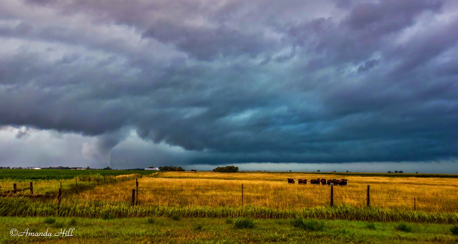
Below are some additional pictures from the day.


Country wide angle view of the storm.


Rain shaft clearly visible with this storm.


Friday, April 10, 2015

Severe Weather Awareness Week Coming up for Minnesota

The header says it all. Spring has sprung in Minnesota - even though with the recent snow showers in the past couple of days doesn't seem to think we'll ever loose our grip on winter.

Severe weather however, is not that far away. Tornadoes and Severe Storms have already occurred as close as Illinois - hitting a small town of Fairdale.

That town - could be any town in MN. Are you prepared? Are you ready?

April 13 - 17th is Severe Weather Awareness Week in MN. Each day has different topics for you to become more weather aware and prepared for the upcoming storm season.

Below is an article that Nick wrote. Remember - be safe, be ready and be prepared.


Wednesday, October 15, 2014

Looking back at the 2014 Season

Looking back at the 2014 Severe Storm chasing season for us... wow what a whirlwind the year was.

It seemed that summer went way to fast.

Stats of the year
Start chasing on April 26 in Nebraska
Ended chasing on September 30th in South Dakota

Chase dates were:
April 26: Nebraska
April 27: Iowa
May 8: Southern MN
May 10: Iowa
May 11: Nebraska Tornadoes
May 25: Rapid City, SD Rain Shower
June 1: Kansas
June 3rd: Moderate Risk Nebraska
June 14: Southern MN Shelf / Iowa Slight Risk
June 16: South Dakota Shelf to Southern MN Shelf
June 21: South Dakota Slight Risk
June 28: Rain Shower and Rainbow
July 7: Central MN Slight Risk
August 23: Faulkton County, SD Tornado
August 24: Benton County, MN Tornado
August 31: Northwest Iowa Slight Risk
September 3: West Central MN Slight Risk
September 20: Sargent County, North Dakota Slight Risk
September 30: South Dakota Slight Risk

States we traveled to this year for chasing:
Minnesota, South Dakota, North Dakota, Nebraska, Kansas and Iowa.

Lots of miles; lots of memories; and 5 tornadoes witnessed. Lots of slight risks; and a couple of moderate risks thrown into there as well.

Below is some of the favorite shots from the season.

September 20, 2014: North Dakota

June 21: South Dakota


June 21, South Dakota


August 24th: Benton County, MN

August 24: Benton County, MN


August 23: Faulkton County South Dakota

August 23: Faulkton County South Dakota

May 11: Nebraska Tornadoes


May 11: Nebraska Tornadoes


May 11: Iowa Night Tornado

Wednesday, September 24, 2014

September 20, 2014: Sargent County, North Dakota Severe Storm


We started out the day in Whapeton, North Dakota at the park where we  enjoyed fall colors and fed the geese and ducks.

 You can tell its fall when the leaves change colors and the geese are returning.


Looking down the river bank.

We knew this wasn't a day of waiting for a storm cloud to pop and intensify;; but a system that would grow stronger into an area that wasn't stable.

We went towards Lingerwood where we went west to try and get south of the storm that was coming into the area. We stopped just north of Havana where FGF put out a tornado warning for possible rotation on the back end charlie of the storm.

Here we took video and many pictures as the storm approached us.

Here Nick is taking video of the approaching storm.


The storm is approaching a bit closer to us now.


This show it looking west into the back end of the cell where the tornado warning was issued for.


Shot of the radar screen shortly after capturing the above photo.

We then proceeded a bit further south to stay out of the rain and hail. Here we were more closer to Havana and the state line.


A look at the upcoming storm more near the town of Havana. We were sitting on County Road 32 in North Dakota.


The sun broke out in front of the storm producing a much different look to the shelf as it neared us.

You can see the precip off to the back.


Nick filming the storm as it approached.


Looking east at the shelf cloud - dealing with the sun breaking out of the clouds by us producing the different colors of the shelf.

We headed south after this dropping the storm until it caught up to us near Sisseton, South Dakota.

Here we encountered only penny size hail and around 60 MPH winds. It was crossing the border; and on radar it was in a big line stretching from Northern MN to Southern MN.

We arrived in Ortonville, MN in no rain and sunshine. We decided to check out the Big Stone National Refuge before heading home.

We were treated to 4 river otters swimming in the river. Pretty rare to see them out in the wild!


What a great little chase today! Not bad for a September storm. Who knows.. we may have another shot in October!

Tuesday, September 16, 2014

9-12-14: Night Photography

September 12 they were claiming that the northern lights were going to be spectacular.

Since we were planning on being in western MN the whole weekend; we said - why not give it a shot!

On our way out to the farm, we got to see a spectacular sunset setting on the town of Chokio, MN


The colors were amazing that night. I'm glad I was able to capture this shot.

We contacted a good friend of ours in the area - Rob Rakow - to see if he was up for shooting some stars and auroras with us that night.

We met a bit after 9pm. The stars were amazing. The clouds moved out just in time.... and the milky way shown brightly before the moon rose.

We met at the "old Stone Barn" on the border of Stevens and Big Stone County.

Here I took at couple of star shots.. and I thought these turned out the best.


The milky way over the old stone barn.. with fain auroras shown.


The old stone barn with the Big Dipper. You can faintly see the green glow of the auroras. The moon was so bright it lit up the stone barn for us.

The moon was just coming off a full moon, so once it rose, it killed having the stars so bright.


The rising moon.

It was fun to hang out with Rob. Doug Kiesling also joined us for some awesome shots of the old stone barn using his came producing IR images. Check out his facebook page for some awesome shots!

8/24/2014 Benton County, MN Tornado


Benton County Tornado


More images and information can be found here:


8/23/2014 South Dakota Edmunds/Faulk County Chase

Spc called out for Slight Risk in South Dakota - near and easy travelling distance for us to chase.

We set out in the prairie land to watch the satellite and enjoy the scenery while we waited for storms to initiate.

Satellite was key this day.


The sky is breaking up!

A storm soon fired up to the west of us. We quickly got on it and this is what it produced!


Sunflower field with the start of the storm.

Looking to the southwest... the start of the 2nd tornado and the ending of the 1st tornado


tornado forming to our west

the radar image at the time the tornado was going on.

Interesting item in this photo. The cows came running out way as if they knew something was happening. The tornado was just off to there southwest. A few minutes later they ran back to the west!

More images and information can be found at our website here: http://www.prairiewindchasers.com/august-23-2014-faulkedmunds-county-south-dakota-tornado/