Nick & I left the Twin Cities metro
area at mid morning for our initial chase target of Fairmont in extreme
southeastern North Dakota. While there we had lunch with a few of the
locals and had a great chat about the upcoming fall harvest as well as
hunting seasons in the area.
After we made the short stop, we
drove just west of town to wait in initiation which did not take to long
as the cold front made swift progress into the unstable environment
lying east toward the MN border all while the turkey towers teased
overhead.
The main player storms began to take off just to our
southwest over Roberts and Grant counties in Northeastern South Dakota
and we got on the storm just northwest of New Effington as it began to
ramp up quickly and became warned on. The storm had a real nice blocky
but small non rotating wall cloud on it nearly right away which quickly
dissipated as the storm warped to outflow mode by the time it reached
I-29.
Below are some pictures from our chase day.
We had lunch at a local Cenex store in Fairmount prior to pre-chase of the day.
After lunch we went to sit outside of town and watched what we call "Turkey Towers" going up to our southwest near Fairmount, North Dakota.
Then we moved south and east into South Dakota where the cells fired up.
Nice Supercell near New Effington South Dakota shortly after initiation east of the cold front.
Supercell
storm ramping up with a nice (VIL) spike just as it went warned by
(ABR) northwest of New Effington South Dakota in northern Roberts
County.
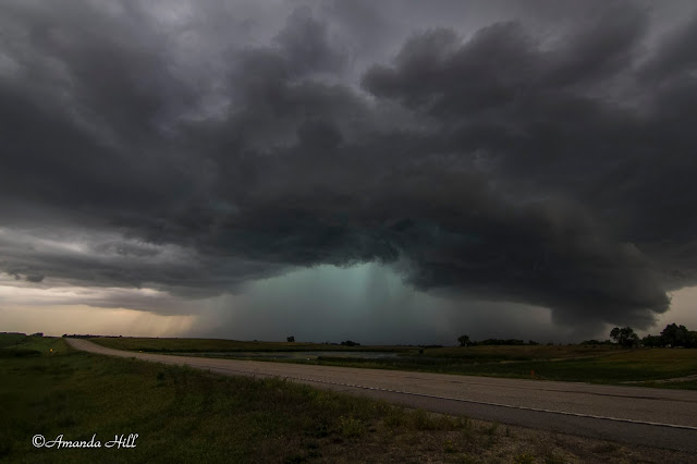
Cell moving east toward Rosholt South Dakota and all OUTFLOW ALREADY! Here comes the shelf!
Large hail back in there on our tail! Notice the blue in color back there? (over the trees) That's the hail core. This means time to move east to stay in front of it!
Back in Minnesota, ahead of the hail core, we stopped again East of Dumont, MN to take this picture of the very well organized shelf cloud in approaching Stevens County.
View looking North and East of the approaching storm entering into Stevens County.
The shelf approaching us closer now. It's almost time to move again!
Before escaping East again, here is a shot looking up at the angry base in Traverse County prior to the storm entering into Stevens County.
Another
shot of the bowl shaped lowering just to our northwest near Dumont MN
in northeastern Traverse county MN as a cell merger was taking place.
Could have tornadoed here if NSE parameters were better.
This
shot was taken just northeast of Dumont MN in northeastern Traverse
County MN when a cell merger took place in front of us and the storm
that was oriented to the east about to get ingested into the line began
to take in inflow and showed us a nice bowl shaped lowering looking up
into the notch. May have been the closest call of the day!
Amazing
Supercell storm with structured dark under anvil/Shelf Cloud/Rain Foot
and closing fast and visible Large Hail Core shown here over a wetland
marsh just east of Donnelly in Stevens County MN.
Another shot from the same area with the shelf getting a bit closer now.
One last shot before moving East of the shelf over the marsh. Note the bright blue off to the left of the screen - that's the hail core approaching us from the west.
After this we drove fast East to stay in front of the massive hail core that this storm was producing. According to our radar; it looked up to baseball sized.
We drove until we got on Highway 28 and starting moving East. We stopped outside of Westport Lake to record wind gust of over 60 MPH with our roof top anemometer. We then continued our way East; this time now staying in the rain; keeping a lookout for any possible damage. We saw a few branches of 2-4" in diameter broken off from trees.
In Sauk Centre we encountered this:
We reported to the National Weather Service the following via spotter network:
Swath of minor wind damage to mainly small to mid sized 3-4 inch
diameter trees in a area from near westport lake east to the western
edge of Sauk Centre. At a farm implement on the west edge of town large
poly cattle feeding troughs were thrown and wrapped around a state
highway sign on hwy 28.
All in all it was a fun chase day in the upper midwest with some photogenic severe storms for the last day of August!


No comments:
Post a Comment