Pages

Saturday, July 4, 2015

June 21, 2015: Bismarck North Dakota


We drove out to Bismarck from the farm that morning. We knew that later in the day we would see severe storms.

We stopped to eat lunch around 2pm in Bismarck, and then proceeded west to the Gladstone Exit.


We stopped at the first of the enchanted highway sculptures - Geese in Flight; to watch on radar and in the distant a storm that was slowly coming our way.


The infamous Geese in Flight right off Interstate 94 at the Gladstone Exit.


Geese In Flight.


Geese metal sculptures line the drive up to the Geese in Flight 


What was left of the storm from the west approaching the geese in flight sculpture area off interstate 94 at the gladstone exit.


We then proceeded to head south on the enchanted highway towards Regent. We saw some other cells coming from Montana off in the distance that were heading east that we thought we could get on down towards south of Regent.


The grasshopper sculpture with the stormy skies behind it.


Pheasant family alongside the road.


When we got to Regent - we headed west on County Road 21. Here we saw the approaching storm from the west. It didn't look great visually.


Looking west on County Road 21.


We then headed east along this road towards Mott, Elgin, up to where it turned north and turned into County Road 6. A mean cell was racing along the interstate towards Bismarck - and we wanted to be on the southern edge of it.

As we sat along County Road 6 - we let it overcome us. Here is what it looked like when it approached from the west.


The leading razor edge that happened on this storm as this beast was bearing down on Bismarck, North Dakota.

Damaging straight line winds of 70 MPH and wind driven golf ball sized hail was with this storm.

Here is the shot that was south and west of Mandan, North Dakota. This was likely the beginning of a long lasting Multi-state MCS that happened downstream into South Dakota and Minnesota to Wisconsin on Monday.

We let the storm overcome us - and after it passed we were treated to some amazing sights.

Mammatus

Rainbows

And an amazing sunset!!!


One of my favorite shots was the blue sky next to the back edge of the cell and a rainbow on the edge.


Sunset after the storm


Never will stop having that love affair with the Dakota Skies. 

This back edge cell was complete with the magic moment of lighting, a glowing well cultivated mammatus field and a full double rainbow as the sun set on the 2015 Summer Solstice.

This was near St. Anthony, North Dakota.


Sunset looking north along the road.


Double rainbow shot to end the day!

You can also view our video footage form the day from the following link:

6-19-2015: South Dakota Magic
We started out our chase vacation by doing it right! - A little bit of South Dakota Magic!

We were watching models and radar all morning; until mid day we start to see warning pop up in Central Minnesota for hail and wind. We saw the cells were moving to the SE near Watertown; so we hurried up and left the farm and headed West.

We went west of Brookings and stopped just south of Hwy 81 and watched the cell come closer. It produced some neat colors in the sky.


The cell approaching from the West.


Looking off to the west.


Awesome colors were produced before the shelf cloud came closer. Here Nick is filming the shelf cloud approaching.


The leading edge approaching from the Northwest.


As the shelf started to approach close; and the lightning got closer we saw also that the big hail was getting closer. So we booked it to the South to Madison, SD. We looked for a place to ride out the hail to make sure we could escape once the storm approached town.

We got video and pics of the approaching shelf cloud coming into town.

This spectacular beauty shown below was on the west end of Madison, South Dakota.

This storm produced wind damages in town (tree branches down) and gold ball sized hail.

These storms developed on the nose of a WAA and also on the edge of the termal gradient in Eastern South Dakota that day.


The approaching shelf coming into town.


Nick and I about to be taken over by the mother like ship in Lake county near Madison, South Dakota. This beast was dramatic with the intense colors as it morphed in shape while maintaining its intensity across Kingsbury and Lake Counties.


The shelf cloud approaching closer


Here is a link to Nick's video that we shot that day: 


Later that night the main deracho started coming across North Dakota - with winds at 80 MPH at Bismark around 9pm that night. It never stayed storng when i t came across Minnesota later that night. Here is a shot of the velocity scan from Bismark at 9pm.


June 9, 2015: Small chase after work


Small pop up showers producing large hail and winds were popping up in Central Minnesota. We went out to Hasty, MN and got into the cell that came through there.

We only was able to capture the rainbow as the storms passed in the Northeast Metro.

These are the only shots that I was able to take from the little chase. The back edge of the cell produce a full rainbow as the sun started to fade.


June 6, 2015: Nebraska


This day the Storm Prediction Center placed an enhanced risk out for Eastern Nebraska. The talk was that tornadoes could happen. They even threw out the 10% hatched for tornadoes.

It started a fun, relaxed chase day early on and seemed more and more all day that something BIG was going to happen. All based on these things we saw coming together.

But it turns out we were correct all along, it just ended up being a fun chase day even though we were hoping it would produce and isolated tornado or two.

We were on the initial cell near O'Neill and Page; which showed healthy signs of rotation. It even produced one legit funnel cloud but it could never become a full tornado.

It was still good to be back on the plains - with great company and friends, and back on some severe storms!

Below are some pictures from the day.


The beginning of this initial supercell beast just Northwest of Page in Holt County Nebraska.

We saw this product a legit small funnel cloud just Northeast of Page; and then that was the day as it just cycled over and over before finally gusting out.


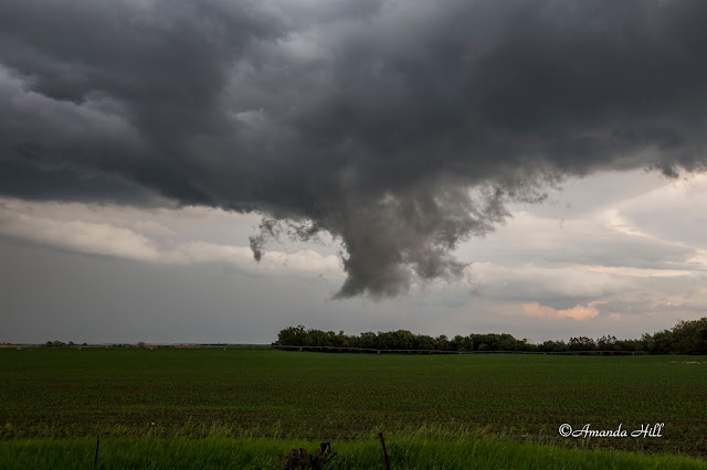
Brief tiny funnel cloud that entertained us for a few seconds near the town of Page. It never did much of anything else afterward. You can see the cool clear slot on the edge of the occlusion.


Making a run at it - just north of Paige, Nebraska. It tried, but it just couldn't fully produce a tornado which to all of use was very surprising!


This is a good skywarn slide. This is scud. It is a funnel look alike. It was actually doing a wild upward rising motion into the updraft base. There was rotation at times, but it produced it way earlier in the day before going through all of the cycling.


Here Nick is taking video on a quiet road in rural Nebraska,


Large scud tag once again... going up into the updraft base just north or Royal, Nebraska.


Now the storm turned into what we call a big convective mess. All the tornado potential is gone here on Nebraska Highway 14.


Here it is, gusting out and trying to attempt to make a shelf cloud over Creighton, Nebraska.

It was time to head home.


Thursday, July 2, 2015

5-17-2015: Central Minnesota Chase


May 17th, 2015.

We sat in Buffalo, MN awaiting towering cumulus to pop up. There was a chance of storms in the area today. After missing out on the tornadoes yesterday, we thought we would give it a shot.

Here is the start of the thunderstorms that popped up in Central Minnesota that day.

Overlooking Buffalo Lake in Buffalo, MN


We didn't see a whole lot with these storms as they really didn't produce, small hail and lots of rain is all we saw. We headed home to the Twin Cities later that afternoon.

Here is a few pictures from the rest of the day.


5-16-2015 Eastern South Dakota Chase

We started our weekend out way west on Friday in South Dakota. With the storms firing way to our south and in Colorado; we licked our wounds and prepped for Saturday's chase in Eastern South Dakota.

We stayed the night in Pierre, SD in position for Saturday's storms.

Saturday proved to be hard as well with the models telling us to move east - and continue to move east. Our targets changed on the fly. We made the best of what the Prairie Coteau of Northeast South Dakota offered to us.

We missed out on the tornadoes back in western Minnesota - but are thankful no big damage occurred and was happy for our fellow chasers who experience these storms.

We instead were treated to some low topped supercell structures and at times - the storms trying to produce but just couldn't along the warm front draped across South Dakota.

Below are some of the pictures from the day.


South Dakota storm trying. Small wall cloud in picture.


Clark County South Dakota Storm


Clark County South Dakota storm


Cumulus clouds forming again in South Dakota.


Storm moving off to the North.


Looking East towards Minnesota, near the border.


Chippewa County Minnesota, tornado warned at this time.


Tornado Warned storm, looking to the south. Chippewa County Minnesota.


Looking to the west as the storm approaches in Chippewa county Minnesota.


The storm went linear and formed a shelf cloud. Chippewa County, Minnesota.

Better look at the shelf cloud. Chippewa County, Minnesota.

A Rainbow to end the chase day - along Highway 40 in Chippewa County.

Wednesday, May 20, 2015

May 10th, 2015: South Dakota Mother's Day Chase

Nick and I officially kicked off the storm chase season by setting up shop Saturday night in Sioux Falls, SD. We didn't want to venture in Southern Kansas with not the possibility of getting back up to NE Nebraska/Southern SD in time for Sunday.

Instead we went and visited Blue Mounds State Park; where we hiked a few trails and saw numerous of birds along the way.


For Sunday we targeted Southern SD and watched the cells fire in Nebraska and head south towards the border.

It was a day where things just didn't quite end of right. We were able to get on cells that were not warned on; and missed the tornado that touched down in the town of Delmont, SD in the morning; as well as the one on the SD/IA border that a few others captured.

It was a fun chase day however; and we were able to fully test out the equipment in full chase mode.

Below are some pictures from the day.

Shot looking to the west of the low topped cells of the day in the afternoon.


Low topped convection trying again to do something; with the warm front earlier that afternoon. It was struggling significantly near the town of Parker, SD.


the closest this cell came to try to produce anything; but just couldn't. The cell was moving North and was headed toward I-90 near Mitchell, SD.