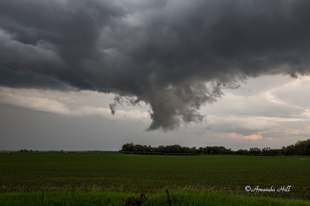
This day the Storm Prediction Center placed an enhanced risk out for Eastern Nebraska. The talk was that tornadoes could happen. They even threw out the 10% hatched for tornadoes.
It started a fun, relaxed chase day early on and seemed more and more all day that something BIG was going to happen. All based on these things we saw coming together.
But it turns out we were correct all along, it just ended up being a fun chase day even though we were hoping it would produce and isolated tornado or two.
We were on the initial cell near O'Neill and Page; which showed healthy signs of rotation. It even produced one legit funnel cloud but it could never become a full tornado.
It was still good to be back on the plains - with great company and friends, and back on some severe storms!
Below are some pictures from the day.
The beginning of this initial supercell beast just Northwest of Page in Holt County Nebraska.
We saw this product a legit small funnel cloud just Northeast of Page; and then that was the day as it just cycled over and over before finally gusting out.
Brief tiny funnel cloud that entertained us for a few seconds near the town of Page. It never did much of anything else afterward. You can see the cool clear slot on the edge of the occlusion.
Making a run at it - just north of Paige, Nebraska. It tried, but it just couldn't fully produce a tornado which to all of use was very surprising!
This is a good skywarn slide. This is scud. It is a funnel look alike. It was actually doing a wild upward rising motion into the updraft base. There was rotation at times, but it produced it way earlier in the day before going through all of the cycling.
Here Nick is taking video on a quiet road in rural Nebraska,
Large scud tag once again... going up into the updraft base just north or Royal, Nebraska.
Now the storm turned into what we call a big convective mess. All the tornado potential is gone here on Nebraska Highway 14.
Here it is, gusting out and trying to attempt to make a shelf cloud over Creighton, Nebraska.
It was time to head home.


No comments:
Post a Comment