Pages

Sunday, September 1, 2013

8-31-13 Eastern SD/Western MN Severe Stroms

Nick & I left the Twin Cities metro area at mid morning for our initial chase target of Fairmont in extreme southeastern North Dakota. While there we had lunch with a few of the locals and had a great chat about the upcoming fall harvest as well as hunting seasons in the area.

After we made the short stop, we drove just west of town to wait in initiation which did not take to long as the cold front made swift progress into the unstable environment lying east toward the MN border all while the turkey towers teased overhead.

The main player storms began to take off just to our southwest over Roberts and Grant counties in Northeastern South Dakota and we got on the storm just northwest of New Effington as it began to ramp up quickly and became warned on. The storm had a real nice blocky but small non rotating wall cloud on it nearly right away which quickly dissipated as the storm warped to outflow mode by the time it reached I-29.


Below are some pictures from our chase day.


We had lunch at a local Cenex store in Fairmount prior to pre-chase of the day.


After lunch we went to sit outside of town and watched what we call "Turkey Towers" going up to our southwest near Fairmount, North Dakota.


Then we moved south and east into South Dakota where the cells fired up.


Nice Supercell near New Effington South Dakota shortly after initiation east of the cold front.


Supercell storm ramping up with a nice (VIL) spike just as it went warned by (ABR) northwest of New Effington South Dakota in northern Roberts County.


 Cell moving east toward Rosholt South Dakota and all OUTFLOW ALREADY! Here comes the shelf!


 Large hail back in there on our tail! Notice the blue in color back there? (over the trees) That's the hail core. This means time to move east to stay in front of it!


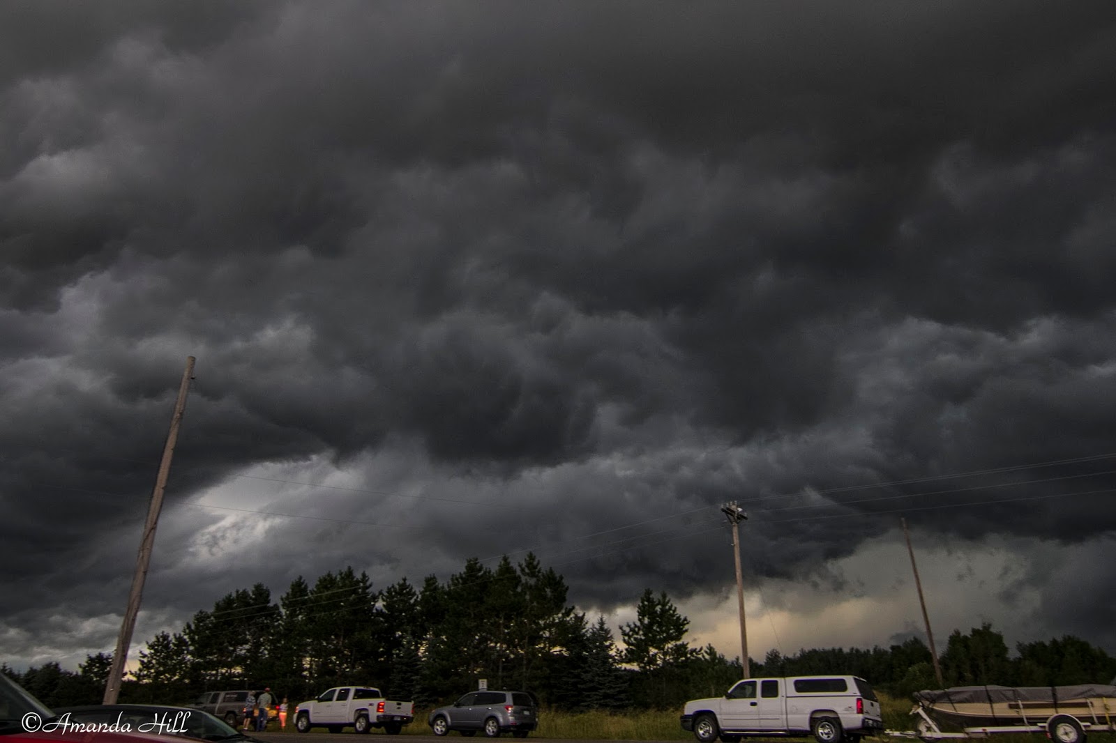
Back in Minnesota, ahead of the hail core, we stopped again East of Dumont, MN to take this picture of the very well organized shelf cloud in approaching Stevens County. 


View looking North and East of the approaching storm entering into Stevens County.


The shelf approaching us closer now. It's almost time to move again!


Before escaping East again, here is a shot looking up at the angry base in Traverse County prior to the storm entering into Stevens County.


Another shot of the bowl shaped lowering just to our northwest near Dumont MN in northeastern Traverse county MN as a cell merger was taking place. Could have tornadoed here if NSE parameters were better.


 This shot was taken just northeast of Dumont MN in northeastern Traverse County MN when a cell merger took place in front of us and the storm that was oriented to the east about to get ingested into the line began to take in inflow and showed us a nice bowl shaped lowering looking up into the notch. May have been the closest call of the day!

 Amazing Supercell storm with structured dark under anvil/Shelf Cloud/Rain Foot and closing fast and visible Large Hail Core shown here over a wetland marsh just east of Donnelly in Stevens County MN.

 Another shot from the same area with the shelf getting a bit closer now.


One last shot before moving East of the shelf over the marsh. Note the bright blue off to the left of the screen - that's the hail core approaching us from the west.

After this we drove fast East to stay in front of the massive hail core that this storm was producing. According to our radar; it looked up to baseball sized.

We drove until we got on Highway 28 and starting moving East. We stopped outside of Westport Lake to record wind gust of over 60 MPH with our roof top anemometer.  We then continued our way East; this time now staying in the rain; keeping a lookout for any possible damage. We saw a few branches of 2-4" in diameter broken off from trees.

In Sauk Centre we encountered this:


We reported to the National Weather Service the following via spotter network:

Swath of minor wind damage to mainly small to mid sized 3-4 inch diameter trees in a area from near westport lake east to the western edge of Sauk Centre. At a farm implement on the west edge of town large poly cattle feeding troughs were thrown and wrapped around a state highway sign on hwy 28.

 
All in all it was a fun chase day in the upper midwest with some photogenic severe storms for the last day of August!

8-29-2013 Aitkin/Cass County Chase

Nick & I started out this great chase day on the Warm Front over Northern Wadena county in west central Minnesota, and as the afternoon turned to early evening the dominate storm of the day got under way over south central Beltrami county.

Knowing the less than favorable road networks to our north in the Big Chippewa National Forest, we quickly raced east through Crow Wing and into Aitkin county where we knew we could intercept the storm in some of the more open visible country of the Jack Pine swamps as it began to take a more southeasterly turn down the arcing warm front near US Hwy 169. As we made the last move to the north near Hwy 210 north of Aitkin it became clear that this was no ordinary storm, but a true Minnesota Northwoods beast!

As Bill Doms once said, "if it looks mean it's mean" and this one sure did look mean!

It was very nerve tingling to see the nervous faces and to hear the voices of early holiday weekend traveler's who were clueless to the storm that lay ahead and were constantly pulling up to ask us what was going on and were was the storm.

Many cabin goers turned around and raced back south as others pulled over and stood down in the ditch.

The storm had the best structure that Nick said he had ever witnessed in Northern Minnesota. He said that it brought back memories from when he was a kid spending the summer with storms on nearby Round Lake in northern Aitkin county. He also said that this brought another past story of a historic Minnesota August tornado from 8-6-1969, the Roosevelt Lake F4 tornado that nearly tracked over and through the same area near Swatera & Haypoint townships in Northern Aitkin county as it tracked up from the southwest on its long and deadly path.

We have sent our findings and a few specific photos on to the Duluth National Weather Service to help further assist in their post storm assessment being conducted in this specific area of Cass & Aitkin counties.

It was a very fulfilling chase day as we got to witness this tornado near the end or its path near Hill City as well as with fellow chasers Doug Kiesling who watched along with us as the beast crossed the road to our North & Bob Conzemius who also witnessed the broad rain wrapped tornado earlier in its lifecycle in Cass county near Remer.


 A beast of a supercell near Hill city Minnesota with spectacular structure as it moved in on our location!


 Leading edge fast approaching us on US HWY 169 near Haypoint Township.


 A shot up into the beast. Our friend Doug Kiesling was just in front of us (car in photo) taking the same shots.

 The broad remnant tornadic circulation approaching US HWY 169 between Haypoint Township and Hill City likely at the end of its northwest to southeast track and likely weak at this point.


 Main action area with broad tornadic circulation south/southwest of Hill City MN.


 One of my favorite shots from the day. This is looking under the shelf; looking east; in a rare open area field up in Northern MN along HWY 69.


Locals and travelers who were nervous and confused created mini traffic jams in the middle of no where as the stormy skies churned overhead!


 Nick shooting video and enjoying the powerful storm as the sun faded in the west and it attempted to do it again near Hassman township north of Aitkin.


Super long inflow tail racing into the storm!


The storm base with decent inflow as the sun sets over Aitkin County near Hassman.


It was a great chase day for a Northern MN