Pages

Thursday, August 13, 2015

August 8, 2015: North Central Minnesota Storms

With the big severe risk down in Nebraska all depending on if the morning MCS and cloud cover could recover; we decided to stay local.

Storms were beginning to build and fire off to our North; so Nick and I went towards the trees of MN and chased the storms that fired between Garrison and Grand Rapids.

We sat just south of Hill City in an somewhat open field area to watch the approaching storm.


Once the hail starting coming our way, we dove south just a bit to the road that goes to Lake Waukenabo. We stayed there until the hail got close, we then drove a bit south and let the hail core pass off to our north.


We drove north to test the winds; and we saw at least dime sized hail along side of the road. We retreated back to the south and to the east a bit to take another look of the storm.


We then proceeded south to head home.

We stopped by a sunflower field (which is rare this far north!) to take a few photos.


We were treated to a nice sunset on the storm that was just north of the metro as we drove home. what a treat!


A fun little chase up in the Northwoods.

Sunday, July 19, 2015

July 5, 2015: West Central Minnesota Cold Front Chase

We enjoyed the holiday weekend out in Western MN. We knew there was a chance of storms on Sunday; and with not wanting to head back to the cities any time soon in the afternoon due to all the traffic heading back in; we stuck out in Western MN waiting for the storms to fire.

The SPC had an enhanced risk out all day for this area.

20150705 2000 UTC Day 1 Outlook Graphic

A cold front in the Dakotas was crossing and was supposed to fire off storms in the afternoon. The models kept showing the storms blowing up over Western MN. We sat waiting in the hot afternoon; full bore sun near Ortonville, MN.

We kept watch for any sign of CU to form off to the west.

Finally something popped up on radar.

We skirted across the border at Ortonville and stopped under a tunnel that went under the railroad bridge. We watched as the storm approached. We thought the hail was coming towards us; but instead it went to the south and west.

Since we saw the storm just not produce anything, we retreated back across the border to MN and started to head our way home via Hwy 12 to Hwy 9 to Hwy 55.

The lightning was weak with the storms as well.

The cold front just stalled and really did not move much at all until way late in the evening.

Below is a shot of the storm when it was near the town of Corona, SD.


The storms just could not get themselves going today with the cold front just stalling out. we headed on back to the cities the back roads as I94 was still full of slow holiday traffic.


July 12, 2015: Western MN Moderate Risk Tornado Day

Since Saturday morning we knew that Western MN would be a big show day - and possible the most severe day in Minnesota this year.

We went out to the farm after stopping by Jessica Becker's graduation party in Buffalo.

We went to watch the fireworks show in Morris for the Prairie Pioneer Days. Below is a couple of shots from the show.


Sunday - we woke up to moderate risk; and started to make sure the people was aware of the situation that could unfold that afternoon. Two big events were in the area. Big Stone County Fair in Clinton and the Prairie Pioneer Days in Morris, MN.

201507121327 PWO graphics
The Public Weather Outlook issued by the SPC @ 8am CDT

The models all kept showing cells to blow up right around the Fairmount, ND area.

With the car set up and all the batteries charged - we set out for Fairmount, ND to wait things out. We had a quick lunch at the gas station and then went and sat and waiting just outside town. We had a few pop up showers come over us, but the cu field was trying to go.

We headed back east to Hwy 75 and went a bit north and sat on a dirt road. This cell was starting to look like it could do something.. and sure enough - we saw a small needle funnel.


The storm as it got going.

A few minutes later this small needle funnel appeared.


another cell showed us a small needle funnel as well.
We went further up the north on Hwy 75 and quickly pulled off by a farmers house; as we saw rapid circulation. As soon as we got out of the car, the tornado appeared. We were looking to the northwest in these following shots. This was just south of the small town of Duran, MN

Shot as it was appearing out from the farmers grove

Getting a better view of the circulation on the ground - whole storm shot.

Tighter shot of the tornado as it was near the edge of the grove

Well formed tornado in this shot.

Tornado starting to become more of a bowl shaped cone.


The tornado quickly was dissipating - and soon would be gone right after this.

Complete rope out stage.

A rule to always to keep your head on a swivel - another tornado was formed and on the ground to our southeast of our location.

Looking Southeast towards the near tornado that did not last very long.

After this we tried to head east to keep up with the storm. We followed it out of Doran, MN - and continued east. We started to run into hail so we dropped back and bit and tried to find a road heading south. We ended up going to Wheaton on some back roads; then onto Hwy 27 towards Herman, MN.

At this point we called our friends for Stevens County EM to give them the all clear as everything went to the East of them.

Outside of Herman, MN along Hwy 27 we ran into Eric Whitehill. We stopped and chatted, and observed the storm from here.

Our two chase vehicles

Eric and Nick
Wannabe cloud - a scud tag hanging from the base of the storm.

We left Eric and headed east towards Hwy 59. We went south on Hwy 59 and then cut east on some gravel road and ended up on hwy 28. We kept going east on Hwy 28, with the storm off to our north.

In Starbuck we stopped to get gas and then went south of town as another tornado warning was issued.
Shot of the storm as it was going over Lake Minnewaska.

Looking north along a side road off County Road 18 in Pope County, MN


Looking east along County Road 18 in Pope County, MN

From here we left the storm. It was starting to go into a line and we wanted to stay ahead of the rain. we made it into the cities around 11pm that night and the rain was just on our tail. We quickly unpacked the necessary items to not leave in the car and called it a night and watched the rain and wind come down.

The Big Stone County Fair thanked us for keeping them in the loop for any potential severe weather and was glad that nothing came there way.

It was a fun little chase day!


Saturday, July 18, 2015

July 17, 2015 Eastern South Dakota Huge Hail & Cool Skies

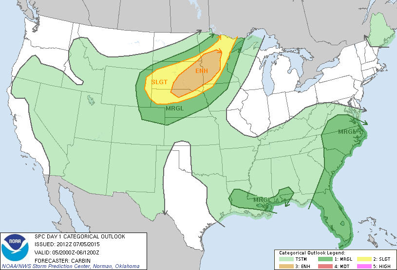
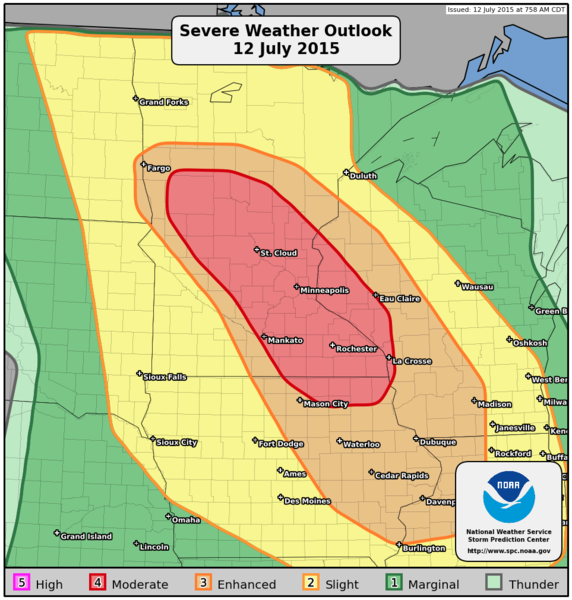
We saw that the SPC put our favorite chasing spot: Western Minnesota and Eastern South Dakota into a slight risk for Friday. Nick looked at the models and said - we need to be on this.

We left the Cities at 11:30am - and was in Eastern South Dakota by 3pm. We watched the birth of the cu field all the way from Glenwood, MN. Once we saw the first blip show up on radar near Britton, SD we knew that was the dominant cell.

We made it to Britton and saw Large hail was coming our way. We escaped to cover under the canopy at a local gas station. The first wave of hail came through with dime sized up to quarter sized hail. Then it rained some. Some people thought it was all over with. Mother Nature had another plan. Round 2 of the hail came through and it packed a mean punch. We saw the smallest size of quarter and the largest up to Tennis Ball sized hail. 3.00 inches!

huge hailstones the fell in Britton

The power went off at the local gas station as the rain and hail just poured.

Finally the hail let up that we were able to head out. We went around town to see if there was any damage. We found some localized flooding; and many 3.0 inch hailstone scattered about the town.

We knew that we wanted to get on the south west side of the storm to see if this thing had any tornado potential with it. We tried to get south but there was no great option of roads East of Britton and the storm kept going along Hwy 10. We had no choice to follow it behind the large hail; stopping when we got so close and had to back off from the storm. We tried to head south on a gravel road and east and ALMOST got the car stuck. We knew then to stick to the tar roads unless the gravel was dry.


Looking east towards the back edge of the storm.


Shot looking down hwy 10 towards the hail core with rainbow in sight.

We had many rewards for stopping and waiting for the storm to proceed east. More baseball sized hailstones. Mammatus Field over the top of our heads. The close lightning strike that was 200 yards away when we stopped to talk with Doug who also was filming the huge hailstones. That was crazy.


Mammatus straight over your head!

Mammatus field looking to the west.


A selection of the hailstones we found along side of the highway.

Hail measuring 2.00 inch and larger

Larger than a golfball!

When we finally reached the outer limits of Sisseton, SD we were finally able to head south on a nice road. We wanted to head towards the Peever exit off the freeway so we could blast south to the Wilmont exit  to cross the border at ortonville.

Looking over the Sisseton Valley Hill at the storm


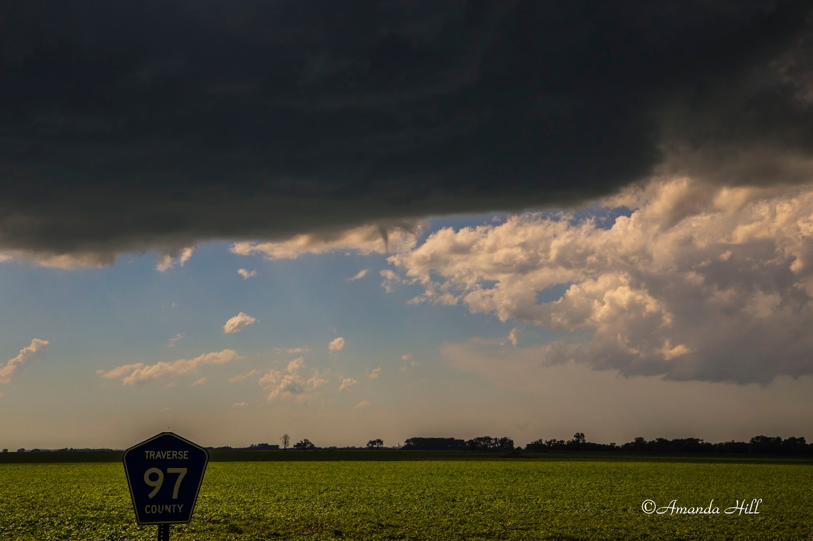
We stopped at the road that head to Peever to view the storm that was out to our west - tornado warned. The lightning had many CG's and we stopped to take video and pictures. It was awesome.


We then took the freeway south to the Wilmont exit where we again headed west a bit on the gravel road to try and see the storm that was producing the rain wrapped tornado off to the west. we got to the top of the gravel hill; the view was amazing - but the lightning was starting to become more frequent and being on top of that high hill - we booked it east to continue towards Wilmont.

Looking west towards the storm. 


Looking West towards the tornado warned storm.

We stopped when we turned on Hwy 109 to photography the nice shelf cloud that was forming on the Eastern South Dakota side.

We then proceeded a little bit further down the road - and got this amazing shot of the mothership.

 Looking down the side of the approaching shelf.


Panoramic shot of the mothership! 


 Shelf approaching closer.

Edge of the shelf nearing the MN/SD border.

We crossed into Minnesota and knew we had to take cover when this beast crossed the border. We took refuge in a do it yourself car wash on top of the hill in ortonville. We were joined by local folks who too were also riding out the wind and hail that was coming towards our way.

After the storm passed - we set out east to photography some wicked crawler in the night sky from the storm passing to the ESE.

The fading sun illuminating the mammatus above


One of the many crawlers that was captured above the corn as the storms moved to the ESE.

After the storm just went too far out of our reach for photos - we packed up and headed up to the farm for the night.

Saturday morning we knew of damage from a tornado report in the town of Waubay. We traveled there in the morning and saw the extensive damage to the trees along the main street; as well as some structural damage; bins down, and campers turned over and destroyed.

The local Red Cross had set up shop to provide assistance for those who needed it. Day County Emergency Services were also on hand, as well as the local Sheriff. Everyone was on clean up duty. The town also had its local doings this weekend and all that fun and play was put on hold to clean up the town and make the roads passable again.

Huge trees were uprooted and tipped over - all laying to the east.


We talked with a local resident on his modular house that was shifted an inch off the foundation from the wind. They just finished the deck on the house and now the big tree branch decided it had other ideas for this deck. There was also a huge branch that was penetrating into the side of the wall. The owner said there was damage to the roof and that 4 rooms in the house sustained extensive water damage. The lucky thing was that no one was home at the time of the storm and no one was hurt.

tree branch that feel on the deck. did not break the table on the deck.


tree branch through the side of the house.

backyard of the house littered with insulation, tree branches and a thrown swing set

We went out to the lakeside campground where many campers were destroyed. We also saw 1 power pole snapped off at its base and was laying down - wires still intact.


We relayed gps coordinates back to the Aberdeen weather service office for their assessment purposes later on.

Below is our two video links. One from the storm and one from the cleanup/damage

https://www.youtube.com/watch?v=HUgau-J4kf4


https://www.youtube.com/watch?v=xiYFbhZpcGM