A day like this comes around few and far between - and one that you will never forget in life. This day is one of those days that both Nick and I will never forget!
Nick and I re-positioned ourselves Friday from Spearfish, South Dakota up to Grand Forks, North Dakota for the big outbreak.
Everything was looking correct. The models kept their consistency with blowing up a huge supercell right over the border and the tornado potential was there.
We woke up in Grand Forks, North Dakota Saturday morning. We stopped at Tim Hortons for a treat and coffee. We then proceeded up to Amanda's friends farm: Lesley Cull - near Cavalier, North Dakota.
We had to make a stop in Cavalier because there was just so many tell tailing sings that seemed to fit the day. Tornado Road? Boundary Road? Home of the Tornadoes? Even a Tornado flavored treat??? IT HAD TO BE A SIGN!


We spent a few hours that afternoon with her; and also getting a mini tour of Walhalla, North Dakota of the gorge. The view was spectacular.

The mighty elk statue stood atop of the overlook near Walhalla, ND
After our short mini tour we ended back up at her house - where we saw the skies start bubbling with CU.

The stormy looking skies starting at Lesley's farm.
We said our goodbye's to Lesley and Mike and headed west and north to almost Walhalla, ND. We stopped at county road 1 as the internet signal was on the verge of roaming with Canada not too far to the north.
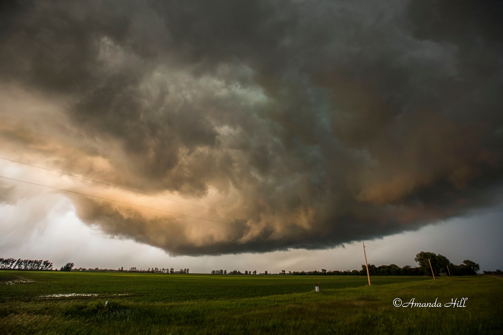
Bill Doms and Eric Whitehill shortly joined us as we watched the massive beast of a supercell makes its exit from Canada.

The shelf like appearance it gave us as it slowly came across the border from Canada. It was going outflow at this point because it wasn't quite into the good USA air yet.

Nick and Bill filming the approaching supercell beast from the North.

Since we had radar up - Nick told the group big hail is coming - we need to move South. So we packed up and booked it south to avoid the large hail.
Once we got south of the storm and on the south west side of it - we pulled off near the town of Gardar where I spotted a small funnel cloud. The funnel cloud then started the series of tornadoes that we saw the rest of that day.

Small funnel cloud in the center of this photo.
This small funnel quickly produced a rope tornado - we headed south on County 32 to stay away from the large hail.
Here is the small rope tornado just south of Town.

Continuing to the South we saw another tornado near the town of Edinburg, ND. Here we pulled off to the side of the road and the tornado was in the field just across from us.

View of the rope tornado just to our west - south of Edinburg, ND.

The tornado reaching for the ground.

As it approaches from the west.

A tall view of the storm producing the tornado just south of Edinburg, ND.


The tornado closely approaching us that we had to make a small move ot the south to stay south of it once again.
Bill Doms was right with us when we watched this beautiful tornado just churn up cinnamon fields from west to east - just north of us. What a memorable day to share with a close friend!


One of my favorite shots of the day. The tornado just east of the road - Bill Doms is in the vehicle in the frame where he too is documenting this remarkable day!

right after crossing the road it picks up the dust/dirt once again.

A view of it as it just crossed the road

Just right after it passsed the road

The tornado now moving east across a field

Nick filming the tornado as it passed to the east.

As it moved to the east still producing the cinnamon swirl from dirt to sky.
After the tornado went east - we continued south. Bill ended up going east after it - and we connected back up with Eric Whitehill as we continued south on County 32; trying to connect up with the next tornadic cell on radar near Logan Center.
We saw the white cone tornado from a distance...

Our view of the white cone tornado from a distance

Our view of the white cone tornado from a distance. this was near Hatton, ND.
We encountered large hail laing on the side of the gravel road, when we stopped at 3rd street NE and 1 Ave NE; 8 miles south of Logan Center.


From here we proceeded south and east - towards Fargo, as all the storms that we were on in North Dakota have moved further South.
South of Fargo; near the Fairmont ND exit we got onto another cell. This one was a beast.
We truly believe that a circulation "albeit -weak" was in contact with the ground with this meso, west of Fairmount, North Dakota in Richland county just before the sun set.
The RFD sent chills down our spines - as we witnessed large tress being snapped and blown over in a field grove just off to our north.
Then winds increased suddenly and were intense, although we did not get an accurate measurement on the, they were truly damaging and we estimated at least a conservative 70MPH.
This was actually the most scary moment of the entire day as a bowl formed and lowered on the meso just as the RFD winds took off and moments later, really appears to be a ground scraping rain wrapped circulation. The tree damage and debris that we drove through support this; as well as the velocity scans at the time.
Bill Doms was also on this storm and witnessed this storm peak in this local area as well. you can take a look at his blog post from this day at the following link: http://mnwxchaser.com/2015images/150627/15june27.html


Here is our video of the Richland event from this time: https://youtu.be/RDUGScYHkWY
5 tornadoes for the day. We followed this beast of the storm all the way to the farm where we warned my parents and people impacted by the storm that large hail was a possibility.
The wind driven hail just hit east of my parents farm; destroying the bean crop at my Uncle's and shredding the corn stalks in the neighboring fields.
In Odessa on another cell; they had huge hail come through where it destroyed vehicles; siding and crops.
This will be one day we will be talking about for years to come - and a day we will never forget.
NWS Grand Forks just recently released the tornado outbreak and ratings for this day. You can read it all here: http://www.weather.gov/fgf/June272015TabSummary
No comments:
Post a Comment